|

|
- Mount St. Helens is the youngest of 15 stratovolcanoes of the Cascade Range from British Columbia to California.
- Mount St. Helens is about 40,000 years old; by contrast, Mount Rainier is about 1 million years old.
- The Mount St. Helens National Volcanic Monument was dedicated in 1982 and is 110,000 acres in size.
- Previous Mount St. Helens eruptive periods:
- 1500 C.E.
- 1800 C.E.
- 1831-1837 C.E.
- Captain George Vancouver named Mount St. Helens in 1792 after Baron St. Helens, an English Diplomat.
|

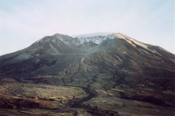
View from Clearwater Ridge October 1999
Photo: EMC
|
|
|
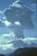
Eruption Facts for May 18, 1980
|
|
| Triggered by | 5.1 magnitude earthquake at 8:32 am |
| Original Height | 9,677 ft / 2950 m |
| Present Height | 8,363 ft / 2550 m |
| Total volume removed | 2/3 cu mi / 2.76 cu km |
| Debris Avalanche |
| Speed | 180 mph / 290 km/h (max) |
| Temperature | 160-212°F / 70-100°C |
| Distance Traveled |
14 mi / 22 km West (Toutle River) (approx.)
5 mi / 8 km North (approx) |
| Depth |
640 ft / 195 m (in North Fork Toutle R.) (max)
150 ft / 45 m (average) |
| Volume removed | 0.6 cu mi / 2.5 cu km |
| Lateral Blast |
| Speed |
Range: 225-730 mph / 60-1180 km/h
Average: 450 mph / 724 km/h |
| Temperature (singed zone) | 120-390°F / 50-200°C |
| Blast Zone | 575-750°F / 300-400°C |
| Blast Area | 230 sq mi / 600 sq km |
| Vertical Plume |
| Height | 15 mi / 24 km (approx.) |
| Duration | 9 hours (approx.) |
| Pyroclastic Flows |
| Speed | 50-80 mph / 80-130 km/h |
| Temperature |
Near Crater: 1380-1560°F / 750-850°C
Most Flows: 570-1350°F / 300-730°C (average) |
| Distance Traveled | 5 mi / 8 km |
| Depth | 130 ft / 40 m (cumulative) |
| Lahars |
| North Fork Toutle River | 65.4 million cu yds / 50 million cu mi |
| Upper Muddy River | 17 million cu yds / 13 million cu mi |
| Speed | Up to 90 mph / 145 km/h |
| Volume | 0.0288 cu mi / 0.12 cu km |
|
|
|
|
|
| Mount Saint Helens Before 1980 |
|---|
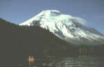
Photo: J. Hughes, USDA Forest Service
From the Mount St. Helens website
|
|
|
|
Quick Facts |
|---|
| Elevations |
|---|
| Coldwater Ridge | 3110 feet | 948 meters |
| Johnston Ridge | 4300 feet | 1311 meters |
| Windy Ridge | 4170 feet | 1271 meters |
| Mount St. Helens (prior) | 9677 feet | 2950 meters |
| Mount St. Helens (after) | 8363 feet | 2550 meters |
| Crater Dimensions |
|---|
| East to West | 1.2 miles | 2 kilometers |
| North to South | 1.8 miles | 4 kilometers |
| Depth | 2100 feet | 671 meters |
| Dome Dimensions |
|---|
| Height | 1000 feet | 305 meters |
| Width | 3450 feet | 1.1 kilometers |
| From Coldwater Ridge |
|---|
| Lava Dome | 8 miles | 12.8 kilometers |
| Base of Mountain | 6.3 miles | 10 kilometers |
| From Johnston Ridge |
|---|
| Lava Dome | 5.5 miles | 8.8 kilometers |
| Base of Mountain | 4.5 miles | 7.2 kilometers |
| From Windy Ridge |
|---|
| Lava Dome | 4.5 miles | 7.2 kilometers |
| Base of Mountain | 2.5 miles | 4 kilometers |
| Coldwater Lake |
|---|
| Length | 4.5 miles | 7.2 kilometers |
| Elevation | 2472 feet | 753 meters |
| Area | 800 acres | 324 hectares |
| Maximum Depth | 203 feet | 62 meters |
| Castle Lake |
|---|
| Length | 1.5 miles | 2.4 kilometers |
| Elevation | 2558 feet | 780 meters |
| Area | 200 acres | 81 hectares |
| Maximum Depth | 105 feet | 32 meters |
| Spirit Lake |
|---|
| Length | 3.2 miles | 5.2 kilometers |
| Elevation | 3475 feet | 1060 meters |
| Area | 3098 acres | 1254 hectares |
| Maximum Depth | 151 feet | 46 meters |
|
|
|
|
|
|
Source:
- Quick Fact Sheet supplied by the U.S. Forestry Service and Coldwater Ridge Visitor Center at the Mount St. Helens National Volcanic Monument. (as updated by Ed K. of USGS on 04/98)
|
View from Johnston Ridge October 1999
Photo: EMC
|
|
|
|
|
Forest Learning Center Facts
The May 18, 1980, eruption of Mount St. Helens sent more than 1,300 feet of the mountain's top cascading into the North Fork Toutle River Valley. Seconds later, a laterally directed blast devastated the surrounding 150,000 acres.
- Nearly 68,000 acres of Weyerhaeuser's St. Helens Tree Farm was located within the eruption blast zone.
- By the fall of 1982, Weyerhaeuser has salvaged 850 million board feet of dead timber. This was enough to build 85,000 three-bedroom homes.
- Weyerhaeuser hand planted 18.4 million Douglas-fir (Pseudotsuga menziesii), noble fir (Abies procera), cottonwood (Populus balsamifera ssp. trichocarpa) and lodgepole pine(Pinus contorta var. latifolia) seedlings on over 45,500 acres in the devastated blast zone.
Source:
- Celebrating the Return of the Forest Bookmark from the Charles W. Bingham Forest Learning Center at Mount St. Helens.
|
|
|
|
|
|
|
For more information on Mount St. Helens, visit:
|
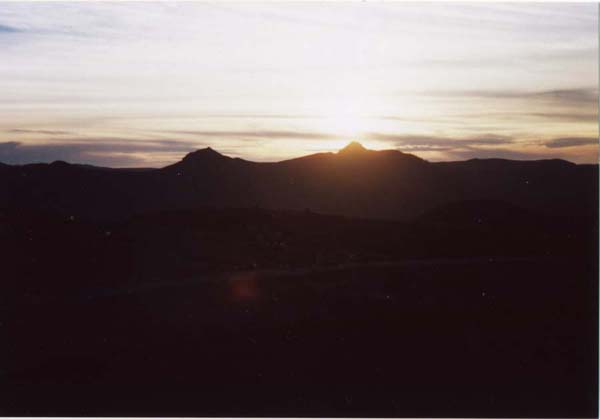
Sunset on the Mountain October 1999
Photo: EMC
|
|
|